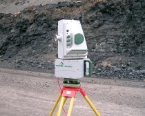
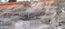
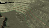
Laser scanner for underground survey

Mining technology innovator Maptek has released a new laser scanner designed specifically for underground applications. The I-Site 8200 is ultra-versatile and can be coupled with a range of accessories to provide a complete scanning system for underground drives, tunnels and stopes, as well as surface stockpiles and silos. Its scan window ranges from -35 to 90 degrees vertically and 360 degrees horizontally. The boom extends up to 10 m into a tunnel or over a void, and the quick release mechanism allows the scanner to be easily removed. The 3D view of the scan on the controller helps the...

Related articles:

Issue 10/2012

Modern and economic quarry and ­resources management

Maptek has a range of products applicable to the needs of the cement industry (Fig. 1). Maptek Vulcan mine planning software can be used for modelling a deposit, planning extraction and managing...

more
Issue 04/2010

New I-Site 8800 laser scanner

Maptek has released a new laser scanner - the I-Site 8800. Stockpile volumes, pit surveys and mapping can be completed faster than ever; even the largest open pits can be modelled in less than a day....

more
Issue 9/2015 MAPTEK

CMC acquires Maptek Sentry for survey and monitoring

Consolidated Mining & Civil Pty Ltd (CMC) has acquired a Sentry monitoring system, manufactured by Maptek, Glenside/Australia primarily for use at the Havilah Resources Limited Portia gold mine in...

more
Issue 02/2010

Survey scan data modelling

Improvements to Maptek’s I-Site Studio 3.3 laser scan modelling software are designed to streamline routine mine surveying tasks. A new global registration tool uses a single step process to register...

more

Survey scan data modelling

Improvements to Maptek’s I-Site Studio 3.3 laser scan modelling software are designed to streamline routine mine surveying tasks. A new global registration tool uses a single step process to register...

more