Modern and economic quarry and ­resources management

Maptek has a range of products applicable to the needs of the cement industry (Fig. 1). Maptek Vulcan mine planning software can be used for modelling a deposit, planning extraction and managing rehabilitation of a quarry. Maptek I-Site laser scanners and I-Site Studio software allow users to scan quarry faces and calculate stockpile volumes.

Economic quarrying

Life-of-mine and stage plans for economic quarrying demonstrate the sequential development of the quarry and illustrate how the plan can be achieved. Vulcan can also identify the impact of improved stone recovery, determine the profitability of stone available for different products, and identify further methods for pit optimisation. In a complex operation materials may need to be blended on site to ensure that the product delivered to customers meets their specifications for manufacturing. Various tools are available for tracking material movement and recording

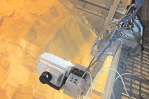
I-Site technology is used for surveying, mapping and volume calculations in the cement industry around the world. The ruggedised I-Site 8000 series laser scanners operate in all environments with high quality data recorded in a short amount of time. With an IP65 rating protection against dust ingress, I-Site laser scanners can be safely used in clinker sheds and industrial environments (Fig. 2). The operating temperature is also critical, with a constant operating range from 0 degrees to +50 degrees Celsius being extended on short exposure from -40 ° to +50 °C.

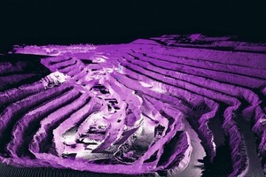
I-Site laser scanners are workhorses when it comes to topographic survey in an open cut quarry. For example, in just four hours a surface area measuring 1500 x 500 m can be scanned from 25 setups. Raw data is loaded into I-Site Studio software to produce a comprehensive 3D model of the active working area. The challenges of scanning stockpiles of clinker, slag, gypsum and limestone are easily met using the I-Site laser scanners. The restricted access of indoor stockpiles is handled by mounting the scanner on a gantry and scanning from above. Volume calculations take just minutes.

Material density can also be determined using the I-Site laser scanners. The scanner is mounted above the  truck loading area and the load is scanned as it is being weighed. A model is developed of each material and is then compared to a model of an empty truck, along with the weight of the truck. This then provides the density of the material in the truck.  


Improvements in efficiency

Sites using Maptek products have seen dramatic improvements in efficiency and productivity. By developing a life-of-mine plan in Vulcan, all departments across the entire operation are on the same page, using the same up-to-the-minute data. Proper planning and forecasting allows the operation to identify the impact of improving stone recovery and determine the profitability of using stone for different products.

Time spent in the field is drastically reduced using the I-Site laser scanners. Using the I-Site Vehicle Mount to allow stop-go scanning means surveying does not interrupt equipment activity in the quarry. The volume of stockpiles is calculated easily by importing data from the I-Site laser scanner into I-Site Studio software. The flexibility to mount the scanner inside sheds or near conveyors means that hard to reach areas can be surveyed effectively.

The long range of I-Site laser scanners (from 1000-2000 m) allows scanning to be conducted remotely, removing the need for site personnel to access unsafe areas or unstable ground. Stockpiles do not need to be climbed on, or unsafe edges approached. Continuous feed mechanisms can continue operating while surveying takes place.

Each year, Maptek invests more than 20 % of its profits back into research and development. New product development and improving existing products are important facets of the business strategy. Maptek products are developed in conjunction with customers and work will continue to provide the solutions which improve the productivity and safety outcomes required by industry.


Case studies

Maptek has been working with cement manufacturers in Australia for several years to scan and produce stockpile models of clinker, slag, gypsum and limestone stored in indoor plant facilities. Keeping track of volumes is a challenging task because of limited access to the shed and strict safety regulations. It is impossible to use tripods for setup due to poor visibility, and constant change to the stockpile shapes prevents interpolation or estimation of volumes. Maptek I-Site laser scanners are the proven solution for keeping track of material stocks in indoor stockpiles. The ruggedised I-Site 8400 can be mounted on 12 m high walkways at the top of the shed to scan the stockpiles from above (Fig. 3). Two scans are taken at each location along the walkway, focusing on the length of the shed and the other on the width. For this 150 m long indoor stockpile, the I-Site 8400 laser scanner was used to acquire 10.7 million fully surveyed (geolocated) points in just 30 minutes. More than 6500 m3 of volume was calculated in 30 minutes. Models are generated to compare quarterly stockpile volumes.

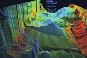
Time to capture data has been reduced by 50 %. Volumes are now calculated with confidence that the data is correct and is an accurate reflection of reality. At another cement facility, an I-Site laser scanner profiled cement inside a silo to better understand how the silo was emptying. The silo was 30 m in diameter and 20 m high, with access from two 0.75 m square roof hatches. The scanner was mounted horizontally and lowered 0.8 m below the roof to achieve 100 % coverage of the cement surface. Over three scans, 1.2 million data points were collected. The data was merged, and unwanted wall and roof data was filtered to create a surface model and contours. The cement surface could then be shown inside the silo.

Within two hours, management had a detailed model of how their silo was emptying, highlighting a significant amount of material remaining on the silo walls and chute. Accurate volumes were easily calculated from the modelled surface which was useful for stocktaking.


Return on investment

Improved accuracy, time and cost savings are the primary ROI demanded by industry. Reducing time spent in the field and in data processing leads to dramatic improvements in productivity. Survey crews can be allocated and used more efficiently. End-of-month pit and stockpile surveys can be easily accomplished within the critical window, allowing time for reporting to management and contractors as well as submissions to the stock exchange. The ability to survey the quarry without interrupting operations reduces expensive downtime for equipment. Providing updated data to planning departments allows for optimal allocation of machinery to active faces. Modelling chute and silo material movements helps to identify material left behind and provide accurate volumes. Reconciling stockpile volumes is critical for defining accurate payments for mining and transportation contractors.
x

Related articles:

Issue 4/2015 MAPTEK

Fast and frequent stockpile volume ­reporting

Mining technology developer Maptek™ has released I-Site™ Drive to provide mines and industrial operations with a faster, more accurate system for frequent stockpile volume reporting. The device...

more
Issue 7-8/2013

Laser scanner for underground survey

Mining technology innovator Maptek has released a new laser scanner designed specifically for underground applications. The I-Site 8200 is ultra-versatile and can be coupled with a range of...

more
Issue 04/2010

New I-Site 8800 laser scanner

Maptek has released a new laser scanner - the I-Site 8800. Stockpile volumes, pit surveys and mapping can be completed faster than ever; even the largest open pits can be modelled in less than a day....

more
Issue 9/2015 MAPTEK

CMC acquires Maptek Sentry for survey and monitoring

Consolidated Mining & Civil Pty Ltd (CMC) has acquired a Sentry monitoring system, manufactured by Maptek, Glenside/Australia primarily for use at the Havilah Resources Limited Portia gold mine in...

more
Issue 02/2010

Survey scan data modelling

Improvements to Maptek’s I-Site Studio 3.3 laser scan modelling software are designed to streamline routine mine surveying tasks. A new global registration tool uses a single step process to register...

more